JavaScript and Cookies are required to view this site. Please enable both in your browser settings.
The Earth Observatory (23 Photos) - Section 2

The Earth Observatory (23 Photos) 

Current Rating:

Unlimited Views No Ads No Algorithms Lifetime Account

Documenting Reality

Community Forum · Est. 2006

Join Now
Thread Tools
  #11  
04-17-2010, 11:09 PM
güttsfükk's Avatar
güttsfükk
Offline:
Super *********
Poster Rank:88
Join Date: Nov 2008
Posts: 17,426
 
Mentioned: 5 Post(s)
Quoted: 99 Post(s)
Activity Longevity
0/20 18/20
Today Posts
0/11 ssss17426
Re: The Earth Observatory (23 Photos)

Steep Antarctic mountains channel the flowing ice sheet into a fast-moving river of ice named Byrd Glacier located near McMurdo Station, the principal U.S. Antarctic Research Base. The glacier plunges through a deep, 15-mile-wide valley in the Transatlantic Mountains to create a 100-mile-long, rock-floored ice stream. This image, captured by the Landsat 7 satellite on December 24, 1999, shows part of the Byrd Glacier flowing through the Transatlantic Mountains.
e11_byrdglacier.jpg
114.1 KB ·68 views
This User Says Thank You For This Post:
vnathan
▼ PROMO FROM DOCUMENTING REALITY
Real Car Crashes & Car Accident Videos
View Now
Hidden for upgraded members.
  #12  
04-17-2010, 11:09 PM
güttsfükk's Avatar
güttsfükk
Offline:
Super *********
Poster Rank:88
Join Date: Nov 2008
Posts: 17,426
 
Mentioned: 5 Post(s)
Quoted: 99 Post(s)
Activity Longevity
0/20 18/20
Today Posts
0/11 ssss17426
Re: The Earth Observatory (23 Photos)

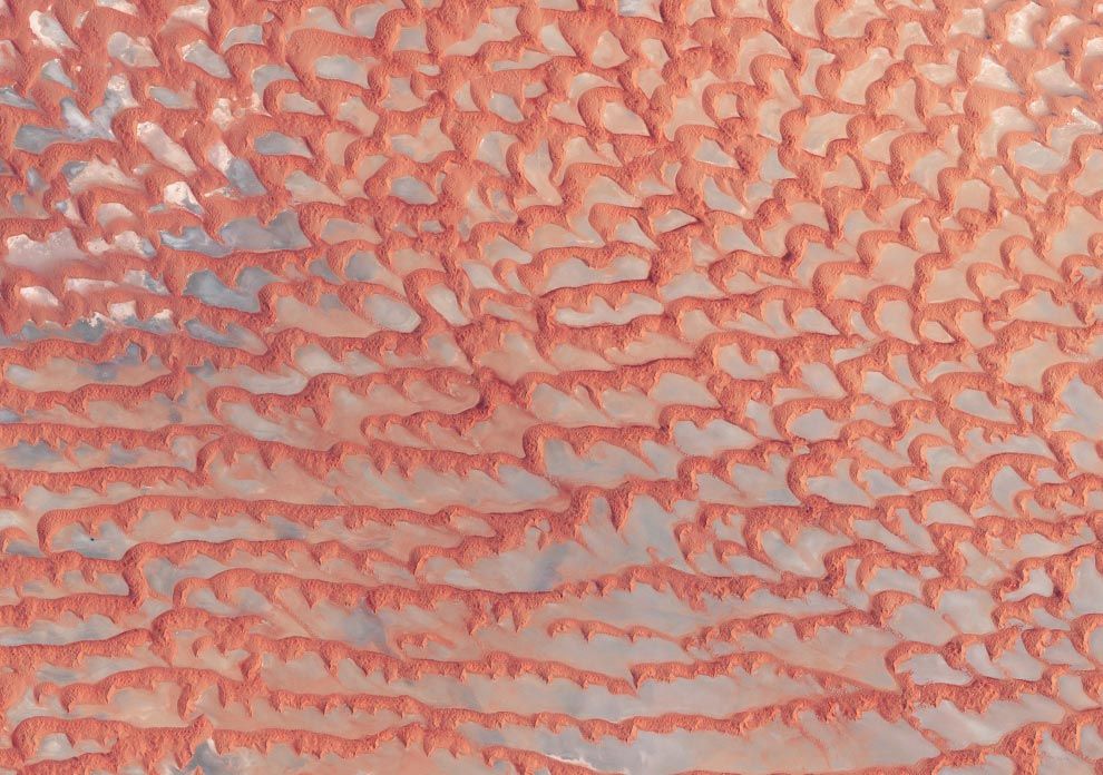
The Arabian Peninsula's Empty Quarter, known as Rub' al Khali, is the world's largest sand sea, holding about half as much sand as the Sahara Desert. The Empty Quarter covers 583,000 square kilometers (225,000 square miles), and stretches over parts of Saudi Arabia, Yemen, Oman, and the United Arab Emirates. The Enhanced Thematic Mapper on NASA's Landsat 7 satellite captured this image of the Empty Quarter on August 26, 2001.
e12_rubalkhali_etm.jpg
148.5 KB ·58 views
This User Says Thank You For This Post:
vnathan
  #13  
04-17-2010, 11:10 PM
güttsfükk's Avatar
güttsfükk
Offline:
Super *********
Poster Rank:88
Join Date: Nov 2008
Posts: 17,426
 
Mentioned: 5 Post(s)
Quoted: 99 Post(s)
Activity Longevity
0/20 18/20
Today Posts
0/11 ssss17426
Re: The Earth Observatory (23 Photos)

In mid-December 2005, the diminutive Amsterdam Island made waves - not in the Indian Ocean where it resides, but in the clouds overhead. The MODIS instrument aboard NASA's Terra satellite captured this image on December 19, 2005. The island itself is almost too small see in this image, but it serves as the starting point for the clouds that flow toward the northeast in a giant V shape.
e13_amsterdam_tmo.jpg
125.8 KB ·99 views
This User Says Thank You For This Post:
vnathan
  #14  
04-17-2010, 11:10 PM
güttsfükk's Avatar
güttsfükk
Offline:
Super *********
Poster Rank:88
Join Date: Nov 2008
Posts: 17,426
 
Mentioned: 5 Post(s)
Quoted: 99 Post(s)
Activity Longevity
0/20 18/20
Today Posts
0/11 ssss17426
Re: The Earth Observatory (23 Photos)

This highly detailed image from the Taiwanese Formosat-2 satellite shows the different sizes, shapes, and textures of ice fragments from an ice shelf on the Antarctic Peninsula on March 8, 2008. Several large icebergs float amid a mosaic of smaller pieces of ice. The level of detail in the image is so great that it can seem as though you are standing over a scale model made out of papier-mâché and foam blocks. The detail can make the bergs seem deceptively small. In reality, some of the large bergs are several hundred meters (yards) long.
e14_wilkins.jpg
174.1 KB ·102 views
This User Says Thank You For This Post:
vnathan
  #15  
04-17-2010, 11:10 PM
güttsfükk's Avatar
güttsfükk
Offline:
Super *********
Poster Rank:88
Join Date: Nov 2008
Posts: 17,426
 
Mentioned: 5 Post(s)
Quoted: 99 Post(s)
Activity Longevity
0/20 18/20
Today Posts
0/11 ssss17426
Re: The Earth Observatory (23 Photos)

This simulated natural-color image of southeastern Fars province in southern Iran shows a dry river channel carving through arid mountains toward the northeast. A broad belt of lush agricultural land follows the curve of the alluvial fan and stretches out along a road that runs parallel to the ridgeline. The valley-ward margin of the intensely green agricultural belt fades to dull green along streams (or irrigation canals). The image was captured by the Advanced Spaceborne Thermal Emission and Reflection Radiometer (ASTER) on NASA's Terra satellite on October 12, 2004.
e15_alluvialfan.jpg
126.3 KB ·104 views
2 Users Say Thank You For This Post:
IRISH., vnathan
  #16  
04-17-2010, 11:11 PM
güttsfükk's Avatar
güttsfükk
Offline:
Super *********
Poster Rank:88
Join Date: Nov 2008
Posts: 17,426
 
Mentioned: 5 Post(s)
Quoted: 99 Post(s)
Activity Longevity
0/20 18/20
Today Posts
0/11 ssss17426
Re: The Earth Observatory (23 Photos)

Tropical Cyclone Billy, seen off the coast of Western Australia on December 25, 2008 by the MODIS instrument on NASA's Aqua satellite.
e16_billy_amo.jpg
61.4 KB ·31 views
This User Says Thank You For This Post:
vnathan
  #17  
04-17-2010, 11:11 PM
güttsfükk's Avatar
güttsfükk
Offline:
Super *********
Poster Rank:88
Join Date: Nov 2008
Posts: 17,426
 
Mentioned: 5 Post(s)
Quoted: 99 Post(s)
Activity Longevity
0/20 18/20
Today Posts
0/11 ssss17426
Re: The Earth Observatory (23 Photos)

This image shows a colorful bloom of phytoplankton throughout the Black Sea on June 4, 2008, along the southern coast near the Turkish cities of Sinop and Samsun. The natural-color image was captured by the MODIS instrument on NASA's Aqua satellite.
e17_BlackSea.jpg
106.5 KB ·34 views
2 Users Say Thank You For This Post:
IRISH., vnathan
  #18  
04-17-2010, 11:11 PM
güttsfükk's Avatar
güttsfükk
Offline:
Super *********
Poster Rank:88
Join Date: Nov 2008
Posts: 17,426
 
Mentioned: 5 Post(s)
Quoted: 99 Post(s)
Activity Longevity
0/20 18/20
Today Posts
0/11 ssss17426
Re: The Earth Observatory (23 Photos)

This image of forest in the northern Republic of Congo was captured on June 27, 2002, by the commercial satellite Ikonos. Dirt logging roads (orange lines) cross the center of the image. This image is one of hundreds of satellite images from commercial and NASA satellites that scientists from the Woods Hole Research Center used to create a map of logging roads and forest disturbance across 4 million square kilometers of tropical African forests in the three decades proceeding 2003.
e18_congologging.jpg
236.9 KB ·92 views
This User Says Thank You For This Post:
vnathan
  #19  
04-17-2010, 11:12 PM
güttsfükk's Avatar
güttsfükk
Offline:
Super *********
Poster Rank:88
Join Date: Nov 2008
Posts: 17,426
 
Mentioned: 5 Post(s)
Quoted: 99 Post(s)
Activity Longevity
0/20 18/20
Today Posts
0/11 ssss17426
Re: The Earth Observatory (23 Photos)

Harrat Khaybar in Saudi Arabia contains a wide range of volcanic rock types and spectacular landforms, several of which are represented in this photograph taken by an astronaut abourd the International Space Station on March 31, 2008. Jabal ("mountain" in Arabic) al Qidr is built from several generations of dark, fluid basalt lava flows. Jabal Abyad, in the center of the image, was formed from a more viscous, silica-rich lava classified as a rhyolite.
e19_ISS016-E-34524.jpg
131.5 KB ·75 views
This User Says Thank You For This Post:
vnathan
  #20  
04-17-2010, 11:12 PM
güttsfükk's Avatar
güttsfükk
Offline:
Super *********
Poster Rank:88
Join Date: Nov 2008
Posts: 17,426
 
Mentioned: 5 Post(s)
Quoted: 99 Post(s)
Activity Longevity
0/20 18/20
Today Posts
0/11 ssss17426
Re: The Earth Observatory (23 Photos)

Two-toned dust plumes blew northward off the coast of Libya on October 26, 2007, as the MODIS instrument on NASA's Terra satellite took this picture. While plumes in the west are beige, reminiscent of the Sahara's sands, the plumes in the east are distinctly darker.
e20_libya_tmo.jpg
73.2 KB ·76 views
This User Says Thank You For This Post:
vnathan


Powered by vBulletin Copyright 2000-2010 Jelsoft Enterprises Limited.

Search Engine Friendly URLs by vBSEO