JavaScript and Cookies are required to view this site. Please enable both in your browser settings.
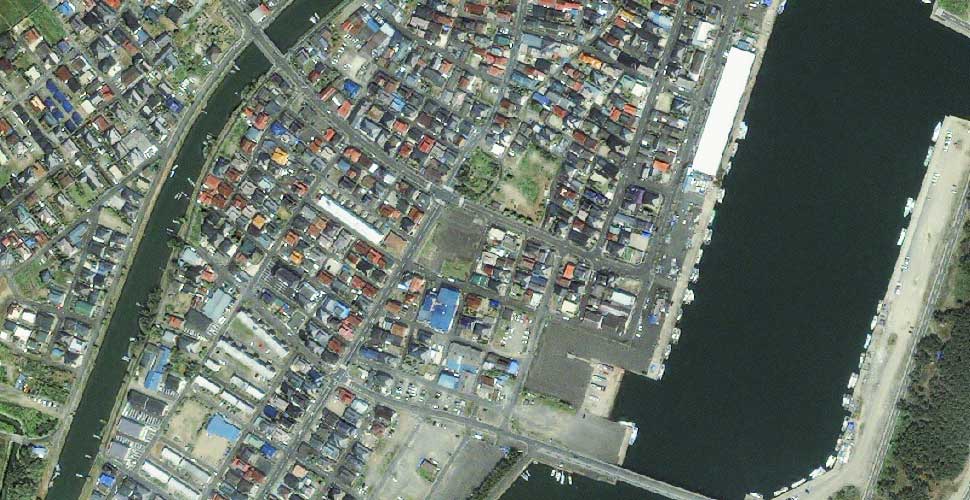
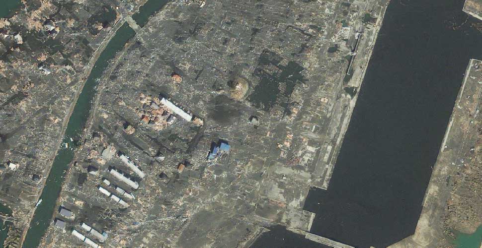
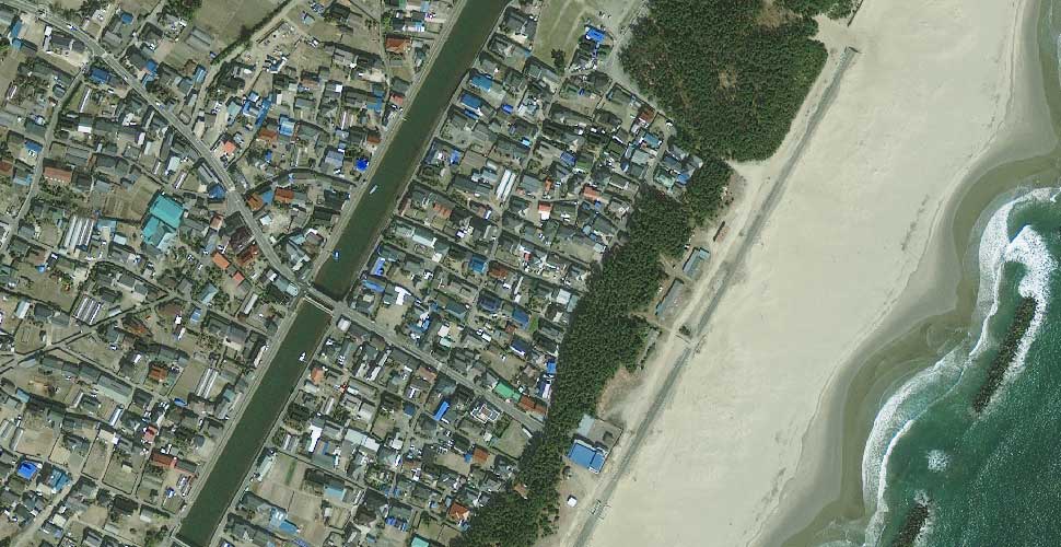
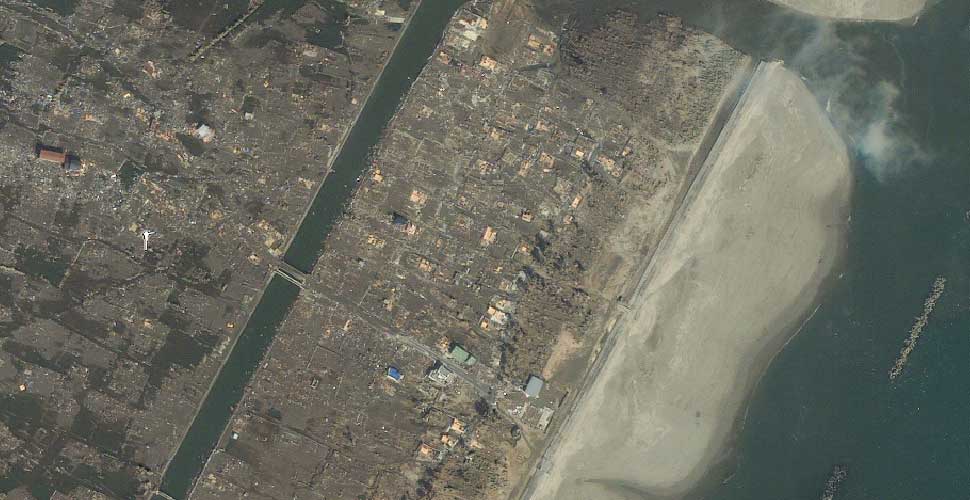
Before & After Satellite Images of Japan's Tsunami Struck Regions.,
Documenting Reality Caught on Camera Natural Disasters & Extreme Weather Events Before & After Satellite Images of Japan's Tsunami Struck Regions.,

Before & After Satellite Images of Japan's Tsunami Struck Regions.,

Current Rating:
Unlimited Views No Ads No Algorithms Lifetime Account

Documenting Reality

Community Forum · Est. 2006

Join Now
Tools ▾
  #1  
● 03-14-2011, 04:33 PM
güttsfükk's Avatar
güttsfükk
Offline: Offline
Super *********
Poster Rank:90
Join Date: Nov 2008
Posts: 17,370
Joined Nov 2008·Rank #90
 
17,370Posts
13,735Thanked
99Quoted
5Mentioned
0Contrib.
Before & After Satellite Images of Japan's Tsunami Struck Regions.,

I'm collecting to make a big thread with a huge collection of images to throw into one thread, but for now :

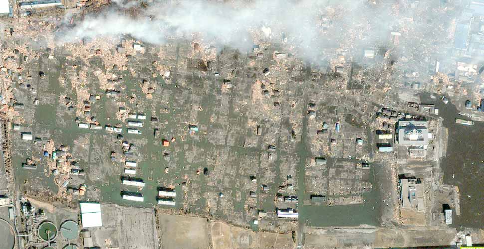
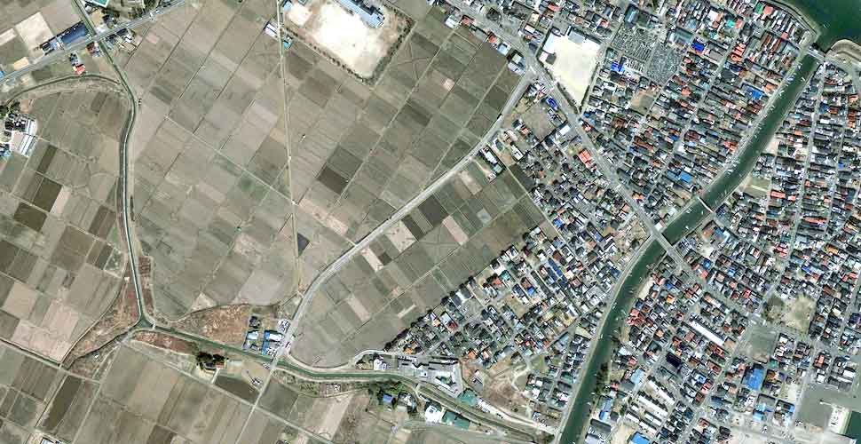
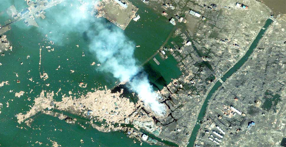
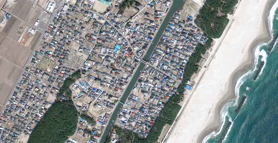
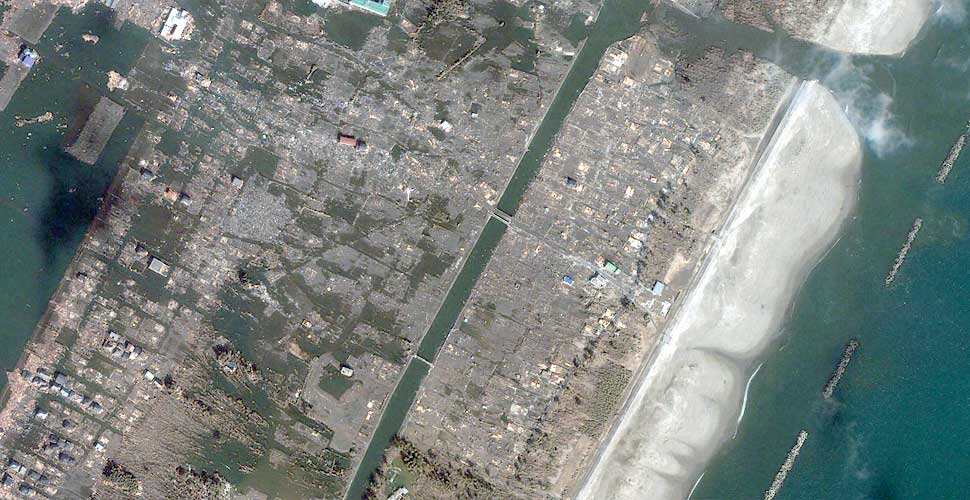
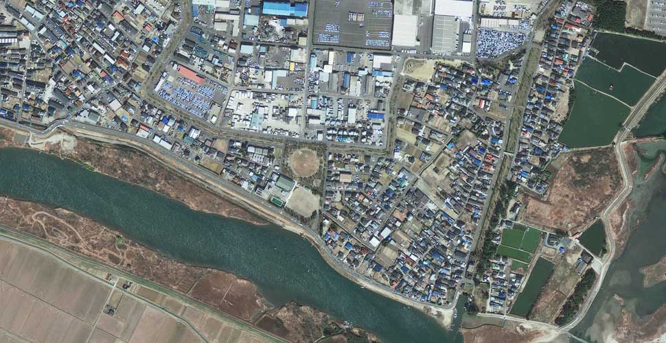
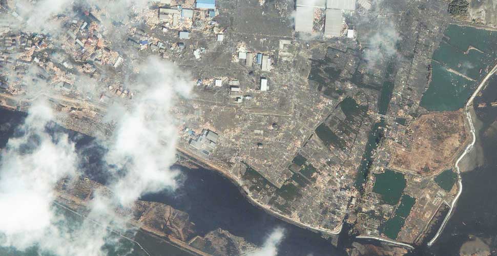
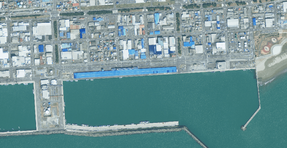
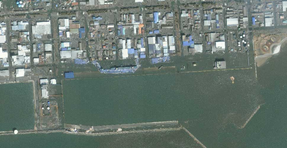
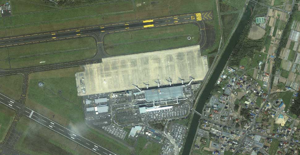
All Before images taken on 4th April 2010 except for the Sendai Airport image taken on 3rd April 2010.

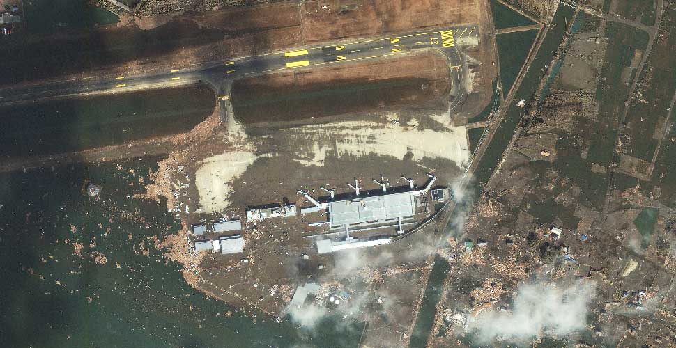
All After images taken on 11th March 2011 on geoeye : http://www.geoeye.com/CorpSite/


ishinomaki
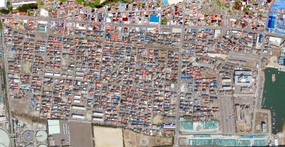
Click image for larger version

Name:	geoeye-ishinomaki-20100404-before.jpg
Views:	474
Size:	136.4 KB
ID:	254132
Click image for larger version

Name:	geoeye-ishinomaki-20110312-after.jpg
Views:	545
Size:	77.2 KB
ID:	254133


Natori
Click image for larger version

Name:	geoeye-natori-tight-20100404-before.jpg
Views:	919
Size:	77.8 KB
ID:	254134
Click image for larger version

Name:	geoeye-natori-tight-20110312-after.jpg
Views:	651
Size:	104.6 KB
ID:	254135

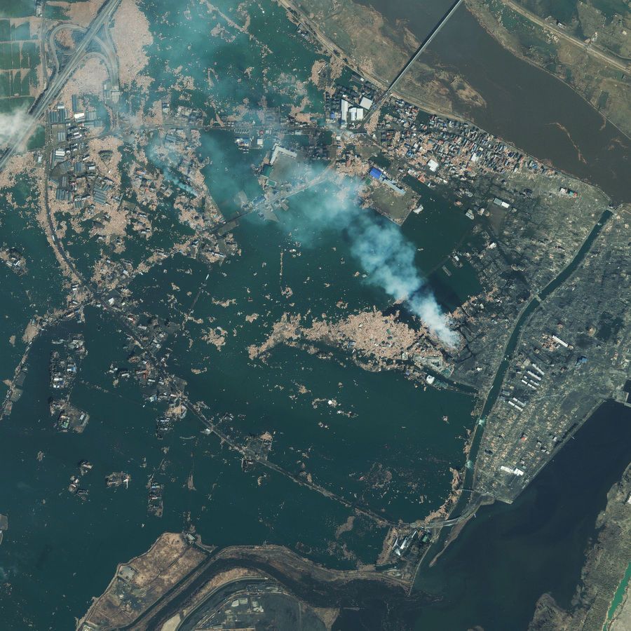
HIGH RESOLUTION (click)
Click image for larger version

Name:	natori_japan_03_12_11.jpg
Views:	433
Size:	208.7 KB
ID:	254168
This one-meter resolution satellite image of Natori, Japan, was taken one day after an 8.9-magnitude earthquake struck the Oshika Peninsula on March 11, 2011. According to news reports, this is the largest earthquake to hit Japan in recorded history and the fifth largest in the world. Analysts believe the powerful earthquake moved Japan’s main island eight feet (2.4 meters), shifted the Earth on its axis four inches (10 centimeters), and unleashed a devastating tsunami. The imagery shows extensive destruction to buildings, vehicles and infrastructure. Entire regions have been flooded, swept away or reduced to ruin. The image was taken by GeoEye’s IKONOS satellite at 10:36 a.m. (local time) on March 12, 2011 from 423 miles in space as it moved from north to south over Japan at a speed of four miles per second.

Sendai
Click image for larger version

Name:	geoeye-sendai-tight1-20100404-before.jpg
Views:	487
Size:	75.4 KB
ID:	254136
Click image for larger version

Name:	geoeye-sendai-tight1-20110412-after.jpg
Views:	942
Size:	92.8 KB
ID:	254137


Sendai
Click image for larger version

Name:	geoeye-sendai-a-20100404-before.jpg
Views:	1726
Size:	104.1 KB
ID:	254138
Click image for larger version

Name:	geoeye-sendai-a-20110312-after.jpg
Views:	538
Size:	72.9 KB
ID:	254139


Yuriage
Click image for larger version

Name:	geoeye-yuriage-20100404-before.jpg
Views:	572
Size:	100.3 KB
ID:	254140
Click image for larger version

Name:	geoeye-yuriage-20110312-after.jpg
Views:	835
Size:	86.4 KB
ID:	254141


Arahama
Click image for larger version

Name:	geoeye-arahama-20100404-before.jpg
Views:	580
Size:	101.7 KB
ID:	254142
Click image for larger version

Name:	geoeye-arahama-20110312-after.jpg
Views:	327
Size:	64.6 KB
ID:	254143


Ishinomaki
Click image for larger version

Name:	geoeye-ishinomaki-b-20100404-before.png
Views:	541
Size:	948.5 KB
ID:	254145
Click image for larger version

Name:	geoeye-ishinomaki-b-20110312-after.jpg
Views:	459
Size:	72.5 KB
ID:	254146


Sendai Airport
Click image for larger version

Name:	geoeye-sendai-airport-20100803-before.jpg
Views:	439
Size:	81.2 KB
ID:	254147
Click image for larger version

Name:	geoeye-sendai-airport-20110312-after.jpg
Views:	481
Size:	82.8 KB
ID:	254148


Source : http://www.nytimes.com/interactive/2...r-tsunami.html
▲ 3 Users Say Thank You For This Post:
Amy, Dragonlady66, gatagato
▼ SPONSORED
Denny Creek Ice Cave Collapse, 2008
Watch on YouTube
Hidden for upgraded members.
  #2  
● 03-14-2011, 04:49 PM
Hunted's Avatar
Hunted
Offline: Offline
idiot savant with a ban stick
Poster Rank:25
Join Date: Oct 2006
Posts: 54,356
Contributions: 29
Joined Oct 2006·Rank #25
 
54,356Posts
6,579Thanked
240Quoted
64Mentioned
29Contrib.
Re: Before & After Satellite Images of Japan's Tsunami Struck Regions.,

some nice photo's gutts
__________________
"Knowledge is often mistaken for intelligence. This is like mistaking a cup of milk for a cow"
  #3  
● 03-14-2011, 05:01 PM
NEVERBACKZ's Avatar
NEVERBACKZ
Offline: Offline
★ Legacy Member ★
Poster Rank:388
male
Join Date: Jan 2010
Posts: 3,081
Joined Jan 2010·Rank #388
 
3,081Posts
1,748Thanked
147Quoted
0Mentioned
0Contrib.
Re: Before & After Satellite Images of Japan's Tsunami Struck Regions.,

Mother nature in all her glory! Greta pics thanks
  #4  
● 03-14-2011, 05:14 PM
güttsfükk's Avatar
güttsfükk
Offline: Offline
Super *********
Poster Rank:90
Join Date: Nov 2008
Posts: 17,370
Joined Nov 2008·Rank #90
 
17,370Posts
13,735Thanked
99Quoted
5Mentioned
0Contrib.
Re: Before & After Satellite Images of Japan's Tsunami Struck Regions.,

high resolution image added for Natori
  #5  
● 03-14-2011, 05:55 PM
Phobophile's Avatar
Phobophile
Offline: Offline
Ien twa trije!
Poster Rank:569
Male
Join Date: Nov 2009
Posts: 1,731
Joined Nov 2009·Rank #569
 
1,731Posts
1,008Thanked
7Quoted
0Mentioned
0Contrib.
Re: Before & After Satellite Images of Japan's Tsunami Struck Regions.,

http://www.documentingreality.com/fo...ictures-73299/
  #6  
● 03-14-2011, 09:09 PM
güttsfükk's Avatar
güttsfükk
Offline: Offline
Super *********
Poster Rank:90
Join Date: Nov 2008
Posts: 17,370
Joined Nov 2008·Rank #90
 
17,370Posts
13,735Thanked
99Quoted
5Mentioned
0Contrib.
Re: Before & After Satellite Images of Japan's Tsunami Struck Regions.,

ach so, i hate it when people are lazy with their posting. dont worry though, i'll clean out this area and dispose of the link only threads later on when i have some time
  #7  
● 03-15-2011, 07:33 PM
vnathan
Offline: Offline
So Fucking Banned
Poster Rank:134
8=====>
Join Date: Oct 2009
Posts: 12,437
Joined Oct 2009·Rank #134
 
12,437Posts
3,839Thanked
0Quoted
0Mentioned
0Contrib.
Re: Before & After Satellite Images of Japan's Tsunami Struck Regions.,

The true extent of devastation can only be seen from the sky
  #8  
● 04-29-2011, 12:11 AM
aserto07's Avatar
aserto07
Offline: Offline
My Rank: CORPORAL
Poster Rank:1611
Join Date: Feb 2009
Posts: 346
Joined Feb 2009·Rank #1,611
 
346Posts
24Thanked
1Quoted
0Mentioned
0Contrib.
Re: Before & After Satellite Images of Japan's Tsunami Struck Regions.,

Documenting Reality Caught on Camera Natural Disasters & Extreme Weather Events Before & After Satellite Images of Japan's Tsunami Struck Regions.,


Powered by vBulletin Copyright 2000-2010 Jelsoft Enterprises Limited.

Search Engine Friendly URLs by vBSEO